- Home
- Geographic Information System
- eRAMS GIS Tools
- Toolbox
- Geoprocessing
Geoprocessing

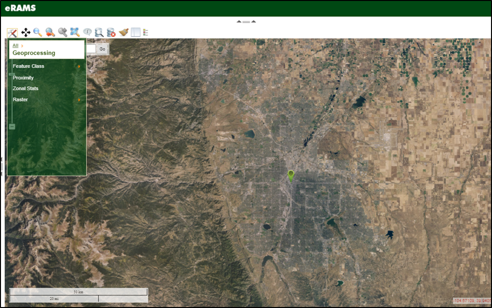
Numerous geoprocessing functions are available in the eRAMS GIS toolbox including tools for working with feature classes, performing proximity operations, obtaining zonal stats, and working with rasters. Click on the Map Tools icon to open the toolbox and select Geoprocessing. Click on the toolset pertaining to the set of operations of interest.
Below you will find detailed information on geoprocessing functions and operations provided by the eRAMS GIS interface.
eRAMS Geoprocessing Tools
Feature Class
Feature Class geoprocessing tools perform operations that use the geometries and attributes of two or more input feature class layers to create an output layer to meet the needs of the user. Options include: Overlay operations such as Clip, Intersect, Union, and Merge, Dissolve functions for removing small polygons, and a Buffer tool.
Learn More
Proximity
The Proximity tool can be used for computing Euclidean Distances between layers and/or Cost Distances through use of a Cost Raster. To open the tool, Click on the Map Tools button to open the toolbox and then click on Geoprocessing. Click on Proximity, which opens a Calculate Distance pop-up box. The first selection will be for the Layer to add the distance attribute to a layer from the user’s Geospatial/User/Project layer pane.
Next, determine if the proximity operation is to measure Euclidean Distance or to calculate Cost Distance. To measure Euclidean Distance between the initially selected layer and another layer, using the Compute distance to: drop-down menu, select the feature class layer of interest. Then determine which method of measurement to use from the using: drop-down menu.
- Centroid finds the distance between the arithmetic mean position of all points in a shape to the arithmetic mean position of all points in another shape. The operation finds the distance between the centroids of the selected layers in meters.
- Closest Edge finds the distance between the closest edges of the layers/objects of interest in meters.
To calculate Cost Distance between features, using the Compute distance to: drop-down menu, select the feature class layer of interest. Then select the raster for use in the cost weighting calculation from the Cost raster: drop-down menu. The distance method is Centroid, which finds the distance between the arithmetic mean positions of all points in the feature class layers of interest and equates distance as a cost factor based on travel through a cell. Cell values cannot be zero.
The results for the feature class layers of interest are displayed in the map window as labels on the features. The labels can be removed by clicking on the layer that the distance attribute was was added to and selecting Turn Labels Off in the pop-up menu.
Zonal Statistics
Zonal statistics are calculated for a specific feature class layer by zone, or areas of same value, based on input values from an input layer that coincides with each zone. The statistics that can be calculated for each zone include minimum (Min), maximum (Max), Mean , Median, Majority, and standard deviation (StdDev).
To use the Zonal Stats tool, click on the Map Tools button to open the toolbox and then click on Geoprocessing. Click on Zonal Stats, which opens a Calculate Distance pop-up box. Select the feature class layer that contains the zones of interest. The layer can be copied to a new layer using the Copy button, the file can be renamed if desired by clicking in the Copy layer to box and changing the name. Click Ok when finished.
Using the drop-down menus in the Choose Layer Attributes for Summary: section of the Calculate Distance pop-up box, select the feature class layer or raster with the attributes to summarize by zone, then select the attribute of interest from the layer that will be summarized, finally chose the desired summary statistic. Click Calculate.
In the pop-up dialog box that appears after clicking Calculate, a new field name can be given for the results by clicking in the Name of New Field: box, then clicking Ok, as the summary statistics are appended to the attribute table of the feature class layer containing the zones of interest. The results also appear on the map as labels and can be removed by clicking on the feature class layer with the zones of interest and selecting Turn Labels Off in the pop-up menu. The Calculate Distance pop-up window can be closed by clicking Done.
Raster
Geoprocessing operations can be performed on raster files. Rasters can be Reclassed, Resampled, and/or raster Calculator functions can be performed. Select Geoprocessing from the Map Tools icon to open the toolbox. Select Raster and then select the tool or interest.
Learn More
