Project B2-2b: Hydrology and Hydraulics of Urban Floodplains
Brian Bledsoe, PhD
University of Georgia
College of Engineering
Novel techniques for analyzing and designing urban drainage and floodplain systems for increased resilience to extreme events can ultimately provide an expanded footprint and palette for design of floodplain-greenspace networks that improve water quality, increase biodiversity, moderate temperatures, cleanse air, and enhance human well-being.
Current research efforts seek to better understand the interactions between flood flows and urban channels, floodplains and riparian zones as influenced by urban infrastructure and efforts to mitigate impacts of urban development, green infrastructure (GI), low impact development (LID), and sustainable urban drainage systems (SUDS) on flood response and other environmental consequences.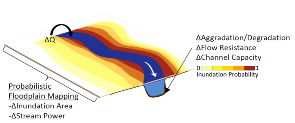
Flood characteristics to be studied include propagation of flood waves, inundation depth and areal extent, velocity and shear stress distributions, hydroperiod, and associated risks to life, property and infrastructure.
Research Questions:
- How does the efficacy of floodplain vs. upland GI for mitigating flood risks vary among regions?
- In what ways does sensitivity of flood risks to prospective solutions vary across regions?
- How do interactions among climate, land use, physiography and GI/LID produce threshold behavior in flood hazards and risks?
Floodplain mapping assisted by modeling of flood hydraulics will represent baseline, development, and various conservation scenarios to examine how integrated GI, LID and SUDS can be strategically designed and positioned to simultaneously enhance flood resilience while providing multiple co-benefits.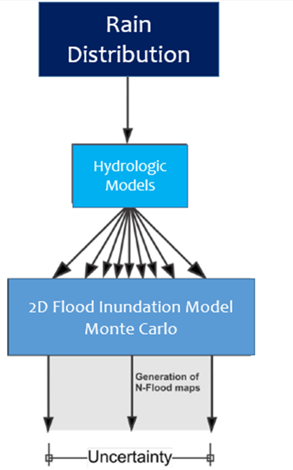
The resulting floodplain inundation maps will be probabilistic and reflect uncertainty quantified through Monte Carlo analysis of model inputs and parameters, competing methods of linking precipitation and land use scenarios to generate flood frequency distributions, and innovative techniques for portraying channel morphodynamics and erosion hazards.
DATA NEEDS
- Existing hydrologic and hydraulic models
- Digital terrain models
- Surveys of in-stream structures (bridges, culverts, etc.)
DATA USE
We intend to use supplied data for model development and risk assessment
Flood Hydraulic Model
We plan to model flood hydraulics utilizing HEC-RAS 5.0.3, a 2-dimensional finite-volume code that solves the shallow-water equations using either a diffusion-wave option or the full St. Venant equations with eddy viscosity coefficients utilized in the turbulence closure.
The primary output data include georeferenced time series of flow depth and x- and y-components of velocity. Model results will be used to delineate inundation extents, spatial and temporal patterns of shear stress, Froude number, and measures of flood-wave attenuation vs translation along a study reach.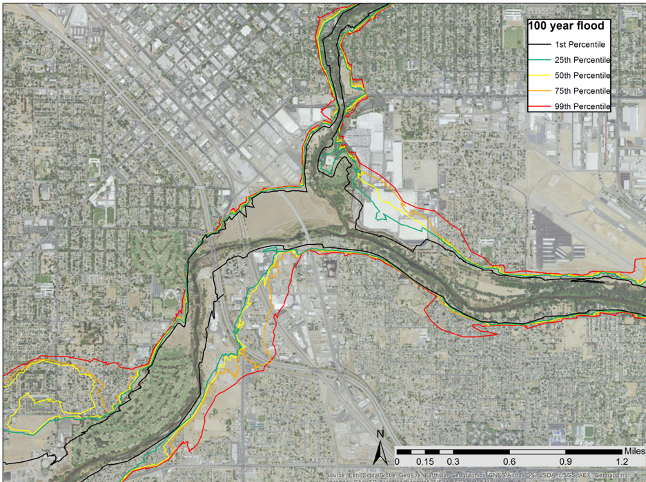
Ultimately, the model will generate flood hazard maps that provide a means for comparative analysis among competing mitigation and hydro-meteorological scenarios while explicitly communicating the uncertainty associated with flood hazard mapping. These results can be used by the broader community to guide individual homeowner and management decisions regarding future development, mitigation strategies, and risk assessment.
Journal Articles
Harlan, Sharon L., Mariana J. Sarango, Elizabeth A. Mack, and Timothy A. Stephens. 2019. “A Survey-Based Assessment of Perceived Flood Risk in Urban Areas of the United States.” Anthropocene 28 (December): 100217. https://doi.org/10.1016/j.ancene.2019.100217
Hoghooghi, N., Golden, H., Bledsoe, B., Barnhart, B., Brookes, A., Djang, K., … & Pettus, P. (2018). Cumulative Effects of Low Impact Development on Watershed Hydrology in a Mixed Land-Cover System. Water, 10(8), 991. https://doi.org/10.3390/w10080991
Lammers, R. W., & Bledsoe, B. P. (2018). A network scale, intermediate complexity model for simulating channel evolution over years to decades. Journal of Hydrology, 566, 886-900. https://doi.org/10.1016/j.jhydrol.2018.09.036
Lammers, R.W., and B.P. Bledsoe. 2018. Parsimonious Sediment Transport Equations Based on Bagnold’s Stream Power Approach. Earth Surface Processes and Landforms, 43(1):242–258, https://doi.org/10.1002/esp.4237
Lammers, R.W., Dell, T.A., and Bledsoe, B.P. 2019. Integrating stormwater management and stream restoration strategies for greater water quality benefits. Journal of Environmental Management, doi:10.2134/jeq2019.02.0084 https://doi.org/10.1002/jeq2.20047
Mazor, RD, May, JT, Sengupta, A, McCune, KS, Bledsoe, BP, Stein, ED. Tools for managing hydrologic alteration on a regional scale: Setting targets to protect stream health. Freshwater Biol. 2018; 63: 786– 803. https://doi.org/10.1111/fwb.13062
Nelson, Donald R., Brian P. Bledsoe, and J. Marshall Shepherd. 2020. “From Hubris to Humility: Transcending Original Sin in Managing Hydroclimatic Risk.” Anthropocene 30 (June): 100239. https://doi.org/10.1016/j.ancene.2020.100239
Nelson, Donald R., Bledsoe, Brian P., Ferreira, Susanna, Nibbelink, Nathan P. 2020. Challenges to realizing the potential of nature-based solutions. Current Opinion in Environmental Sustainability, 45: 49-55. https://doi.org/10.1016/j.cosust.2020.09.001
Sengupta, A., *S.K. Adams, B.P. Bledsoe, E.D. Stein, K.S. McCune, and R.D. Mazor. 2018. Tools for Managing Hydrologic Alteration on a Regional Scale: Estimating Changes in Flow Characteristics at Ungauged Sites Freshwater Biology, 63(8), https://doi.org/10.1111/fwb.13074
Sholtes, J.S., *S.E. Yochum, J.A. Scott, and B.P. Bledsoe. 2018. Longitudinal Variability of Geomorphic Response to Floods. Earth Surf. Process. Landforms, 43(15), https://doi.org/10.1002/esp.4472
Stephens, T. and Bledsoe, B (2017). Urban floodplains: Changing climate, land use, and river channels. Regions Magazine https://doi.org/10.1080/13673882.2017.11878968 Status = Published Acknowledgement of Federal Support = No; Peer Reviewed = Yes
Stephens, Timothy A., and Brian P. Bledsoe. 2020. Probabilistic Mapping of Flood Hazards: Depicting Uncertainty in Streamflow, Land Use, and Geomorphic Adjustment. Anthropocene 29 (January): 100231. https://doi.org/10.1016/j.ancene.2019.100231.
Stephens, Timothy A., and Brian P. Bledsoe. 2020. “Low-Flow Trends at Southeast United States Streamflow Gauges.” Journal of Water Resources Planning and Management 146 (6): 04020032. https://doi.org/10.1061/(ASCE)WR.1943-5452.0001212
Updated: May 2021
Tools/Technologies
Probabilistic floodplain mapping framework based on Monte Carlo simulations of flood hydraulics that accounts for uncertainty in model inputs and parameters.
Collection of UAV imagery processed using Structure from Motion (SfM) software to generate high-resolution topographic point clouds used in 2d hydraulic models of flood waves routed through pre- and post-restoration channel/floodplain systems
Rapid Evolution Model (REM)
Updated: May 2019
Theses/Dissertations
Stephens, Tim A. 2020. Quantifying Honest Reliability Under Uncertainty And Nonstationarity With Probabilistic Floodplain Maps. Ph.D. Dissertation, University of Georgia. Web: https://esploro.libs.uga.edu/esploro/outputs/doctoral/QUANTIFYING-HONEST-RELIABILITY-UNDER-UNCERTAINTY-AND-NONSTATIONARITY-WITH-PROBABILSTIC-FLOODPLAIN-MAPS/9949365539902959
Updated: May 2021
Related Materials
 Brian Bledsoe, PhD – Principal Investigator
Professor
College of Engineering
University of Georgia
Voice: (706) 542-7249
Email: bbledsoe@uga.edu
Brian Bledsoe is a professor in the College of Engineering at the University of Georgia. Brian has over 25 years of experience as an engineer, hydrologist, and environmental scientist in the private and public sectors. He holds degrees from Georgia Tech, North Carolina State University, and Colorado State University. Before entering the professorate, he worked in the private sector as a consulting engineer and surveyor, and for the State of North Carolina as a watershed restoration specialist and state nonpoint source program coordinator. Brian’s research is focused on the interface of hydrology, ecology, and urban water sustainability with an emphasis on green infrastructure including streams, floodplains, and stormwater systems. He received an NSF CAREER Award in 2006, and served as a Fulbright Scholar in Chile in 2008. Brian’s scientific advisory and peer-review activities include the Everglades and Louisiana Coastal Area restoration efforts, the Platte River and San Juan River Recovery Implementation Programs, and the EPA Environmental Monitoring and Assessment Program. He is a licensed professional engineer in NC and CO.
Andrew Miller, PhD – Professor
University of Maryland, Baltimore County
Geography and Environmental Systems
Email: miller@umbc.edu
Tim Stephens, Ph.D. Candidate
University of Georgia
Email: tas48127@uga.edu
Gina Lee, Ph.D. Candidate
University of Maryland, Baltimore County
Email: ginalee1@umbc.edu