Project D1-1: Modeling present and future values for sustainable water management blueprint indicators
Mary Santelmann, PhD
Oregon State University
College of Earth, Ocean, and Atmospheric Sciences
This project provides insight into how different urban water management strategies may mitigate risks and create resilience to pressures from climate and socioeconomic change. It is developing a tool for modeling future conditions of urban water systems, and regionally pilot the use of urban water sustainability indicators to measure the vulnerability, reliability and resiliency of current and future water management strategies and technological innovations. The project is working with regional stakeholders from the Willamette Valley, Oregon to identify realistic assumptions for futures scenarios and identify regionally-relevant water management solutions.
A key element of the project is its multiscale, stakeholder driven approach. We are working with a regionally representative stakeholder group to depict neighborhood (~150 ha.) and watershed (~4000 ha.) expressions of three alternative futures scenarios, and are using those depictions to model urban water sustainability indicators appropriate for those scales. We are pairing neighborhood and watershed-scale indicators with basin-scale (~3,000,000 ha) indicators that assess regional pressures and trends that also affect water supply and demand.
MAPS & DATA PRODUCTS
Hulse, D., Enright, C., Branscomb, A., Santelmann, M., Wright, M. 2018. Multiscale Scenario Narratives for 2060 Urban Water Management, Willamette River Basin. Institute for a Sustainable Environment, University of Oregon.
Hulse, D., Enright, C., Branscomb, A., Santelmann, M., Wright, M. 2018. Land Use Land Cover for 2010 and 2060 Alternative Futures, Chicken Creek Watershed near Sherwood, Oregon (10m rasters). Institute for a Sustainable Environment, University of Oregon.
Hulse, D., Enright, C., Branscomb, A., Santelmann, M., Wright, M. 2018. Neighborhood Site Plans for 2010 and 2060 Alternative Futures Scenarios, West Sherwood Neighborhood, near Sherwood, Oregon. (polygon shapefiles). Institute for a Sustainable Environment, University of Oregon.
DATA INPUTS
- Regionally downscaled climate projections
- Population projections
- Geospatial land, water, and demographic data
- Pipe networks for the cities of Portland and Eugene
DATA OUTPUTS
Data outputs include map-based visualizations and indicator-based metrics that highlight potential tradeoffs between different urban water management approaches.
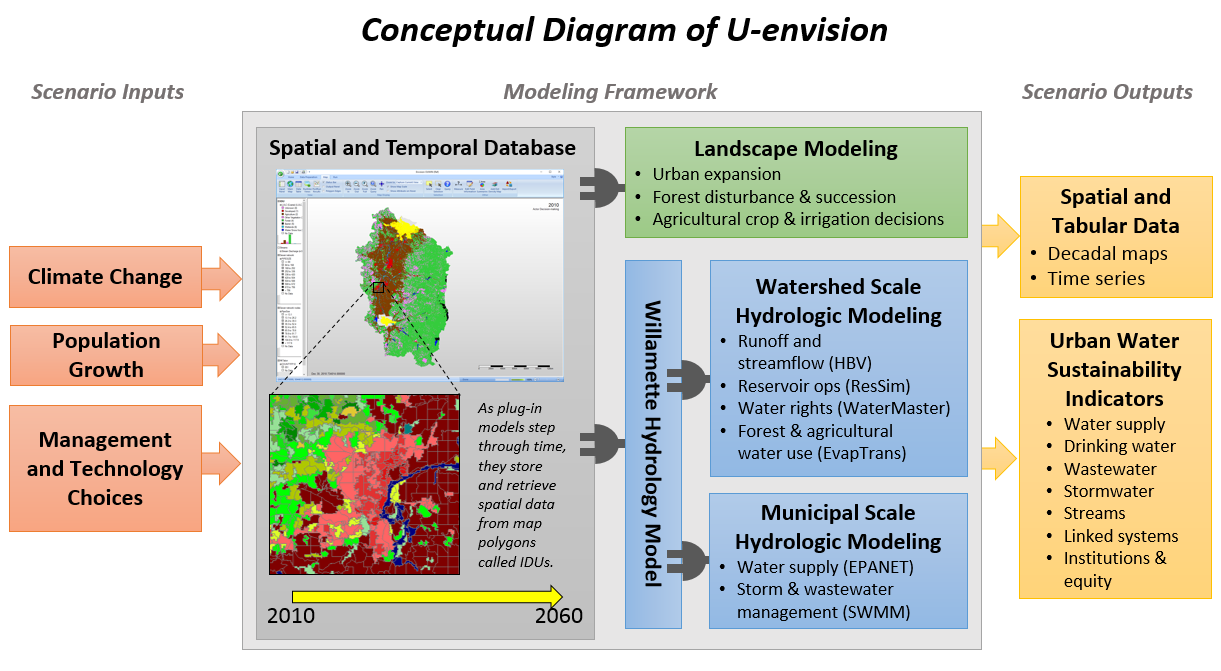
UWINnvision Model
The project is developing U-envision, a tool to visualize and explore tradeoffs between different urban water management strategies and responses to the 21st century challenges of population growth and climate change. The model builds on Willamette Envision, a whole watershed model that represents natural and human influences on water supply, demand and hydrology. Envision has been widely used to conduct model based scenario assessments incorporating both biophysical and sociocultural dimensions of landscape change. As part of this project, researchers will increase the resolution of municipal scale modeling for an urbanizing watershed near Portland Oregon, while maintaining the perspective of a whole watershed model.
Books/Chapters
Santelmann, M. Hulse D., Wright M., Enright C., Branscomb A., Tchintcharauli-Harrison M., Talal, M. 2020. Innovation in Urban Water Systems. In: T. Fisher, B. Orland, and C. Steinitz (Eds.), The International GeoDesign Collaborative: Changing Geography by Design; Redlands, California. ESRI Press.
Journal Articles
- Ibsen, P., D. Borowy, T. Dell, D. Hondula, H. Greydanus, N. Gupta, T. Meixner, M. Santelmann, S. Shiflett, M. Sukop, C. Swan, M. Talal, M. Valencia, M. Wright, G. Jenerette. 2021. Greater Aridity Increases the Magnitude of Urban Nighttime Vegetation-Derived Air Cooling. Environmental Research Letters. Res. Lett. 16 034011 https://doi.org/10.1088/1748-9326/abdf8a
- Santelmann, M.V., D. Hulse, M. Wright, C. Enright, A. Branscomb, M. Tchintcharauli-Harrison, J. Bolson. 2019. Designing and modeling innovation across scales for urban water systems. Urban Ecosystems. https://doi.org/10.1007/s11252-019-00882-6
- Talal, M.L. and M.V. Santelmann. 2019. Plant community composition and biodiversity patterns in urban parks of Portland, Oregon. Frontiers in Ecology and Evolution 04 June 2019. https://doi.org/10.3389/fevo.2019.00201
- Talal, M.L. and M.V. Santelmann. 2020. Vegetation management for urban park visitors: a mixed methods approach in Portland, Oregon. Ecological Applications https://doi.org/10.1002/eap.2079
- Talal, M.L. and M.V. Santelmann. 2020. Vegetation management for urban park visitors: a mixed methods approach in Portland, Oregon. Bulletin of the Ecological Society of America. 101(2):e01674. https://doi.org/10.1002/bes2.1674
- Talal, M.L. and M.V. Santelmann, and J.H. Tilt. 2021. Urban park visitor preferences for vegetation – an on-site qualitative research study. Plants, People, Planet. 3(4):375-388. doi: 10.1002/ppp3.10188
- Talal, M.L. and M.V. Santelmann. Visitor access, use, and desired improvements in urban parks. Urban Forestry and Urban Greening. 63, 127216. doi.org/10.1016/j.ufug.2021.127216
- Tchintcharauli-Harrison MB, Santelmann MV, Greydanus H, Shehab O and Wright M (2022) Role of Neighborhood Design in Reducing Impacts of Development and Climate Change, West Sherwood, OR. Front. Water 3:757420. doi: 10.3389/frwa.2021.757420
- Wright, M, M.V. Santelmann, K. Vaché, and D. Hulse. 2021. Modeling the impact of development policies and climate on suburban watershed hydrology near Portland, Oregon. Landscape and Urban Planning. https://doi.org/10.1016/j.landurbplan.2021.104133
Updated: November 2022
Theses/Dissertations
Talal, M. 2019. Exploring Urban Parks: Plant Communities, Visitor Experiences, and Manager Perspectives in Portland, Oregon. PhD Dissertation. Oregon State University, Corvallis, OR. Web: https://ir.library.oregonstate.edu/concern/graduate_thesis_or_dissertations/4m90f2149
Updated: July 2020
Maps & Data
Hulse, D., Enright, C., Branscomb, A., Santelmann, M., Wright, M. 2018. Multiscale Scenario Narratives for 2060 Urban Water Management, Willamette River Basin. Institute for a Sustainable Environment, University of Oregon.
Hulse, D., Enright, C., Branscomb, A., Santelmann, M., Wright, M. 2018. Land Use Land Cover for 2010 and 2060 Alternative Futures, Chicken Creek Watershed near Sherwood, Oregon (10m rasters). Institute for a Sustainable Environment, University of Oregon.
Hulse, D., Enright, C., Branscomb, A., Santelmann, M., Wright, M. 2018. Neighborhood Site Plans for 2010 and 2060 Alternative Futures Scenarios, West Sherwood Neighborhood, near Sherwood, Oregon. (polygon shapefiles). Institute for a Sustainable Environment, University of Oregon.
Related Materials
Updated: May 2022
 Roy Haggerty, PhD – Principal Investigator

Associate Vice President for Research and Hollis M. Dole Professor of Environmental Geology
College of Earth, Ocean, and Atmospheric Sciences
Oregon State University
Voice: (541) 737-0663
Email: haggerty@oregonstate.edu
Dr. Haggerty has been dean of the College of Science since 2017 and a faculty member at OSU for more than 20 years. An exceptional scholar and earth scientist, Haggerty’s research in hydrology and geology has been applied to nuclear waste disposal problems in the United States and Sweden, to groundwater contamination, and to transport of nutrients, carbon and heat in streams. While on sabbatical in Spain, Haggerty and colleagues developed a smart tracer for quantifying metabolism in streams. His research has been supported by more than $9 million in grants and contracts from the National Science Foundation, the Department of Energy, the Environmental Protection Agency, the USDA Forest Service and other U.S. and international organizations, resulting in more than 65 peer-reviewed publications. His highly cited 1995 paper on mass transfer of solutes in groundwater, co-authored by his thesis advisor, Steve Gorelick, was recognized by the International Association of Hydrological Sciences as one of the all-time “benchmark” papers in groundwater, a body of work that extends from Henry Darcy’s foundational publication in 1856 to the present day.
David Hulse, Philip H. Knight Professor
Director FIBER
University of Florida, College of Design, Construction and Planning
Email: dhulse@uoregon.edu
Mary Santelmann, Associate Professor
College of Earth, Ocean, and Atmospheric Sciences and Director, Water Resources Graduate Program
Oregon State University
Email: Mary.Santelmann@oregonstate.edu
Allan Branscomb
Institute for a Sustainable Environment, University of Oregon
Email: allanb@uoregon.edu
David Conklin
Oregon Freshwater Simulations
Email: david.conklin@FreshwaterSim.com
Chris Enright
University of Oregon, Institute for a Sustainable Environment
Email: cenright@uoregon.edu
Maria Wright
Oregon State University, Institute for Water and Watersheds,
Email: maria.wright@oregonstate.edu
Students:
Michael Harrison, Ph.D. student
Oregon State University, Water Resources Science
Email: harrimic@oregonstate.ed
Michelle Talal, Ph.D. student
Oregon State University, Environmental Sciences
Email: talalm@oregonstate.edu