Thermal Images
Authors
- Laura Salazar – Princeton University
- Hongshan Guo – Princeton University
- Dr. Gideon Aschwanden – Princeton University
- Dr. Forrest Meggers – Princeton University
Purpose
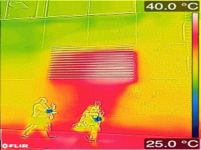
Thermal images to measure surface temperatures in the urban environment and observe variations before and after rain events, and with respect to latent and sensible cooling equipment.
Description
Thermal images were taken in New York City to observe the variation in surface temperature in the summer and the relationship to urban infrastructure and climate variations. The images were taken in large urban canyons to observe variations due to solar loadings, green infrastructure, and building/infrastructure geometry creating urban canyons. Images were also taken before and after rain events to observe latent cooling effects and capacitance of wet surfaces after rain. Finally images were taken around cooling equipment that was rejecting heat to the environment either via direct sensible air heat exchangers (window air con) or by wet cooling towers (commercial roof mounted evaporative cooling towers).
Meggers, F., Aschwanden, G., Teitelbaum, E., Guo, H., Salazar, L., & Bruelisauer, M. (2016). Urban cooling primary energy reduction potential: System losses caused by microclimates. Sustainable Cities and Society, 27, 315–323. https://doi.org/10.1016/j.scs.2016.08.007
Attributes
The thermal images contain Flir metadata for temperature at each pixel recorded by the Flir microbolometer array in an 80x60 array.