Project B2-2b
Project Lead: Brian Bledsoe – University of Georgia
Project Overview
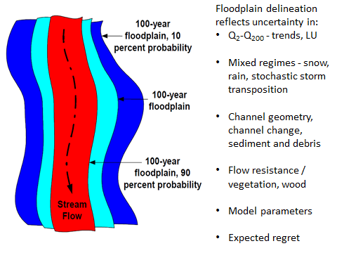
Figure 1. Explicitly addressing uncertainty in floodplain inundation during extreme events can potentially expand the footprint and palette for design of urban floodpoain-greenspace networks that provide many co-benefits.
Novel techniques for analyzing and designing urban drainage and floodplain systems for increased resilience to extreme events can ultimately provide an expanded footprint and palette for design of floodplain-greenspace networks that improve water quality, increase biodiversity, moderate temperatures, cleanse air, and enhance human well-being. This project addresses the interactions between flood flows and urban channels, floodplains and riparian zones as influenced by urban infrastructure and efforts to mitigate impacts of urban development (green infrastructure (GI) and low impact development (LID)) on flood response and other environmental consequences in six locations: Colorado Front Range, Baltimore, Phoenix, Los Angeles, S. Florida, and Pacific Northwest (Portland or Puget Lowlands). This effort is fundamentally linked to project B2-2a which provides a suite of hydrologic modeling scenarios that will be used to drive floodplain hydraulic models in the six study regions. Floodplain mapping assisted by modeling of flood hydraulics will represent baseline, development, and various conservation scenarios derived from Envision to examine how integrated low impact development and GI, LID and sustainable urban drainage systems (SUDS) can be strategically designed and positioned to simultaneously enhance flood resilience while providing multiple co-benefits. The resulting floodplain inundation maps will be probabilistic and reflect uncertainty quantified through Monte Carlo analysis of model inputs and parameters, competing methods of linking precipitation and land use scenarios to generate flood frequency distributions, and innovative techniques for portraying channel morphodynamics and erosion hazards.
In addition to developing procedures for design of urban drainage and channel/floodplain corridors to increase resilience to extreme flooding, the resulting floodplain maps will provide a platform for examining the efficacy of expanded GI and naturalized floodplains for water quality and biodiversity (project A3-2), moderating temperatures (project A2-3) and improving human well-being.
Recent Comments